The White Horses of Wiltshire

June 14, 2017 – White Horses of Wiltshire
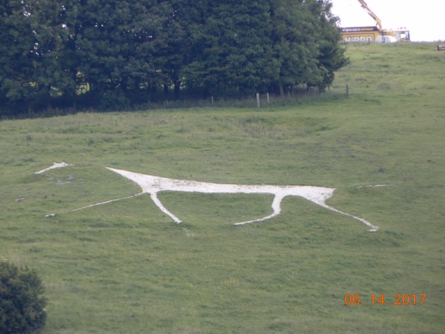
England has a collection of gigantic chalk figures carved into hillsides throughout the southern countryside. They range in type from human figures to military crests to horses. The horses are probably the most common, and in Wiltshire – where we happened to be at the time – there are six in the area.
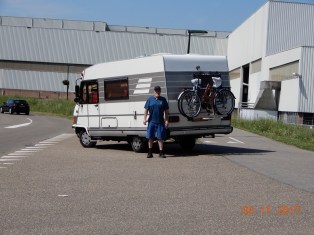
After spending the night at a camping just outside Devizes we consulted the map and began our quest.

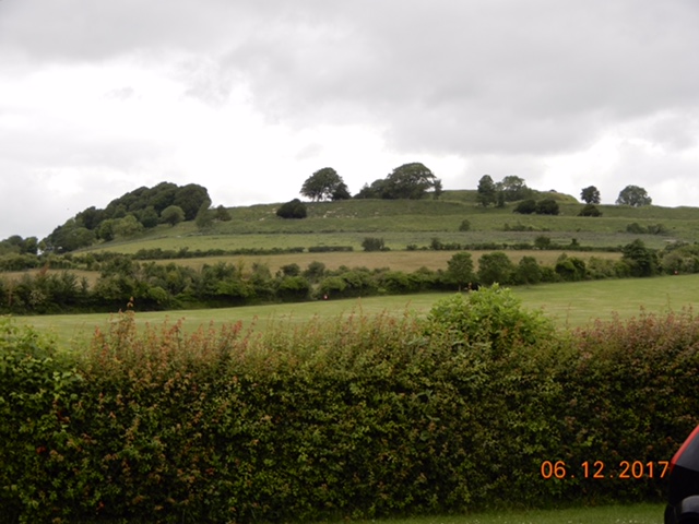
According to written references, these white horses were carved out of the hillsides anywhere from 150 to 250 years ago. The turf is dug up to reveal the chalk hillside underneath, thus the name White Horses. They are 100’s of feet tall and can be seen from quite a distance away. Some communities actually have periods when the denizens make a day of it freshening up the figures by weeding out the new grass and resharpening the outlines.
To find them we set out on another series of small roads through delightful little villages. Our first find was the Roundway White Horse just north of Devizes. We were able to stop alongside the road and take our zoomed in photos.

8E14148C-DA23-41CE-8043-36D1D69A848E0F71370C-370E-4265-9641-BD987976AFF1

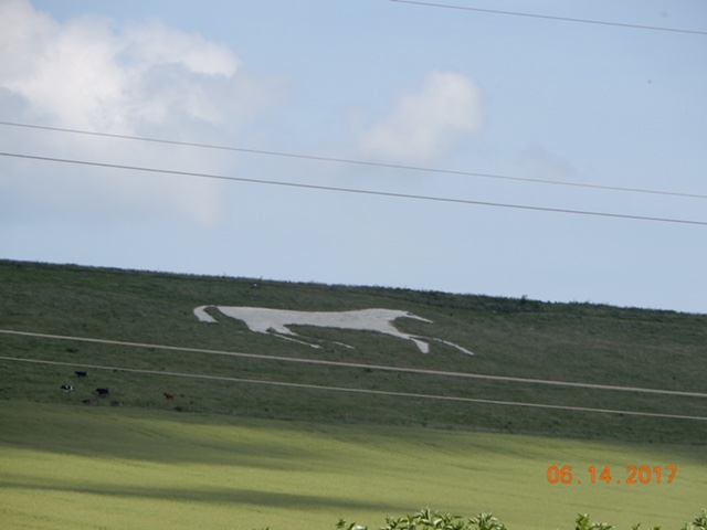
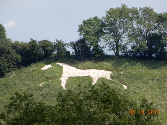
Then it was off to Cherhill, a few miles away, where we parked at a footpath pull-off to snap another couple of zoomed photos. The need for zoomed photos is that we can’t get very close to the Horses without loosing perspective, and the roads don’t get that close anyway.
Along with the Cherhill Horse are the remains of an Iron Age hill fort. One of those famous British footpaths leads up to them, and had we the time, we could have enjoyed a hike up to the top with 3 ladies waiting for us to get our camper out of their way so they could begin theirs.
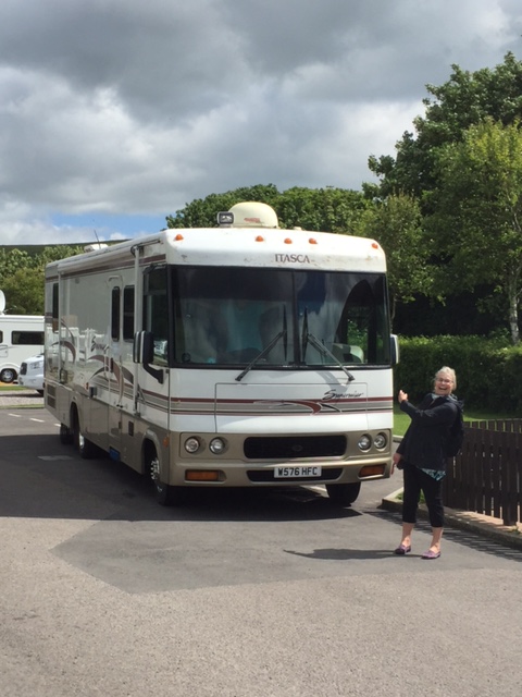
Pulling out of our parking spot was interesting: we had to reverse our position (make a 180* turn around – in a parking space made for 2 cars) carefully because we were on the wrong side of the road. To continue our quest we had to make a right hand turn on a blind corner. In England, remember, one drives from the left, so a right hand turn crosses lanes just like our left hand turns do in the States.

IMG_102674F28C85-1454-43EC-A0EB-F640BCC466254F456AFF-EBF5-4BB8-B4E9-A19BD7077D67
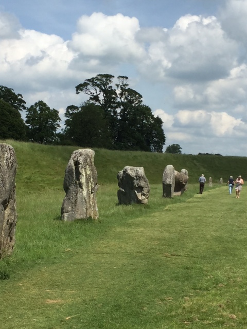
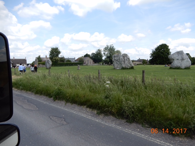
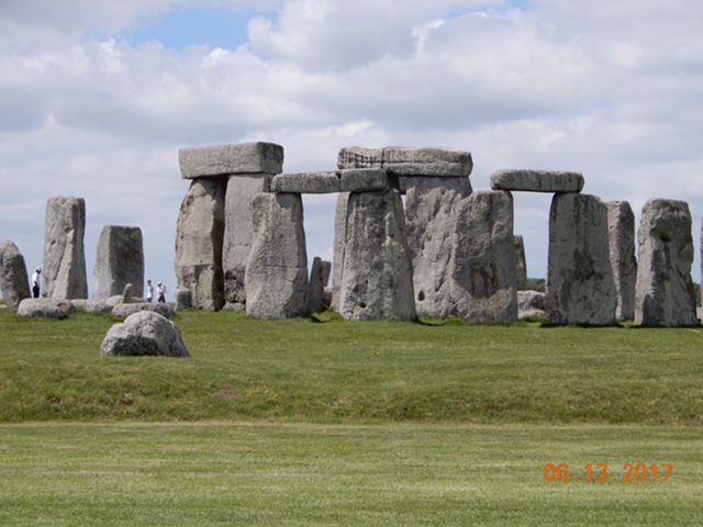
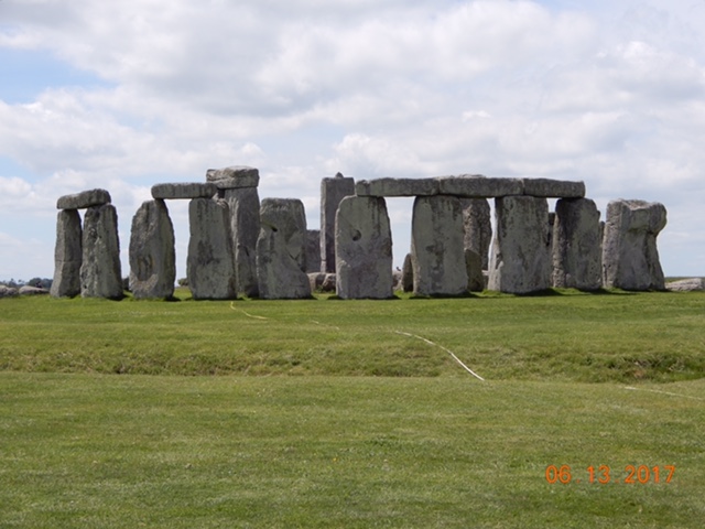
Our next stop was Avebury, famous for its huge circle of standing stones whose diameter is nearly a mile. The town sits right in the middle of the circle. Avebury is an English Heritage site so we were able to park for free and explore the area. The town was lovely with thatched roof cottages (cottage is a misnomer – at least to me, who thinks small when I hear that word – because they are larger than my home – and much more charming) a Norman church in the middle of a graveyard and a manor house with well tended gardens. And the standing stones in their natural un-hewn state. The difference between these stones and the ones at Stonehenge is remarkable. If the Stonehenge stones started out like these, a lot of work was put into shaping them.

470695E1-1858-4845-8F28-3A84251F753748133861-76EA-45E7-ABFF-53B8BE602546
A few miles past Avebury was the Winterbourne White Horse – we had to drive up a private road to get our photo – and our last White Horse was at Broad Town along a long uphill well-traversed road.
Our drive was roughly oval shaped beginning at Devizes and ending at Swindon where we were hoping to find a caravan store to get a couple of parts we are in need of. The distance from Devizes to Swindon is 26 miles on the direct route but our ambling was probably closer to 40 miles.
Swindon was large and of course our route led us pretty much through the center, although the roads were larger and consequently faster- everyone is in a rush!
It was around 2:30 by this time. We were ready to get to the Cotswolds and we needed to find a place for the night. Consulting our camping books we found a Caravan Club camping outside one of our designated Cotswold towns – Bourton-on-the-Water – and made for it.
The Cotswolds are a stretch of hills beginning near Bath and heading northeast for about 80 miles. They are known for their distinctive colored stone and the beautiful towns made from that stone. The hills aren’t good for farming but were great for sheep raising and the towns became rich from the wool trade in the 1600s.
To get to our camping we took (another) side road that took us up and down hills and through tunnels of greenery on one lane roads. We passed through a couple of small villages before we found our camping and realized if we hadn’t turned off that side road we still could have arrived there in a much easier – but boring – way. The camping was interesting. There is no shower or toilet block, use your own facilities (thank goodness we have them) and that’ll still be 14 quid, thank you very much. It will only be a one-nighter for us, not only for the lack of facilities but it is 5 miles away from town so we must drive to see anything. Once we are on the road we ain’t coming back.

Salisbury and Stonehenge

6/13/17 – Salisbury and Stonehenge
Monday morning we had a bad scare about Bruce’s back – somehow while in bed it acted up and he couldn’t get out of pain the entire night. We were both pretty discouraged but he took an ibuprofen 800, did some stretching exercises and declared himself ready to walk into town.
Great Britain is covered in public footpaths – thousands of miles worth – and they are used quite extensively by the public. One path is right outside the campground and a short 1.5 mile walk took us into the heart of Salisbury, following the river Avon.

0C02059F-EE3D-4025-A71A-C824078DD65F
River Avon with Cathedral Spire in background

Our foremost reason for visiting Salisbury is the magnificent cathedral in the center of town but walking along the river we revisited the past via the architectural mix of old and new buildings that are 200 – 400 years old. They are build in brick or stone or are half timbered filled with brick or plaster. Walking down the streets of Salisbury you feel like you have walked back into the time of Queen Elizabeth Tudor. The McDonalds sign hanging on the corner of a 1700s building is what anchors you to the 21st century.

We walked through a stone gateway into the cathedral close. Unlike nearly all churches and cathedrals in the UK and on the continent, this close is unique; it is 80 acres of open grassy space on which the cathedral is centered. The perspective this allows for is wonderful. Most great cathedrals are set in compact squares with shops and markets crowding them and allow for no sense of magnificence the buildings deserve. Not so in Salisbury. Not only is there space to appreciate the structure but the cathedral is commanding in its own right.


Begun in 1220 AD, most of the work was completed in a mere 38 years. It has the tallest spire in the UK at 404 feet. When you look at the completed project you can’t help but appreciate the mastery of the stone carvers who worked on the project. Statues of saints, churchmen, kings and queens adorn the fronts. The cloisters – a covered walkway usually facing a garden area – is the largest and one of the loveliest in England. The chapter house – a meeting place – houses one of the four surviving original copies of the Magna Carta. It is noted for is octagonal shape and decorative medieval friezes that depict scenes from the Bible. When the cathedral was built, few people outside of the church could read or write. They were taught about the stories in the Bible by way of stained glass windows and carvings. The chapter house friezes are stone carvings telling Old Testament stories like The Creation, Adam and Eve and their expulsion, Noah’s Ark, Sodom and Gomorrah.


Because of time and natural elements, the cathedral must be continuously maintained. Stone carvers still work there, replacing worn stone from large statues to small pediments. We spent a short time watching a young man carving a cornice with hand tools.

We left the cathedral close and as we worked our way to the bus stop we came across the Poultry Cross –a market cross marking the former site of the poultry market. There used to be four such crosses in Salisbury including a cheese market, a livestock market and a wool or linen market. These “crosses” marked the area where local authorities granted towns the right to hold regular markets.
Finally, after a quick stop at a Tesco Market for bread and hair mousse we jumped the bus to return to the camping.
We are pleased to report that Bruce’s back is much improved and the day’s excursion did not harm him, and in fact, may have helped.

B121CACA-276F-4EB3-A786-A493EF1CDE8B
New city of Salisbury viewed from Old Sarum

Tuesday before driving to Stonehenge, we knew we had to visit Old Sarum.It was a two-fold purpose; to see the castle remains and to join the English Heritage Trust, an association that controls over 400 worthwhile sites to see in Great Britain. Because we are old, we were able to join the senior membership for £70 for 2 for a year. That is £35 each for a year’s membership. To enter Stonehenge without membership alone is £18 each so we will make our money back quickly.
After Old Sarum, we drove to that iconic group of standing stones erected about 4,500 years ago whose purpose is still unknown despite numerous theories.

DSCN0769DSCN0772

Stonehenge sits in the center of Salisbury Plains next to a very busy highway which takes away from its grandeur. Whatever engineer decided on that move should have been fired immediately rather than have his plan enacted. It does, however, give the casual driver a chance to see the World Heritage site.
We were late arriving at Stonehenge and did not beat the crowds that come in with the touring buses.
We were two among a gazillion tourists walking the demesne looking like ants following a trail of crumbs. The site is so awe-inspiring the crowds couldn’t diminish the impact. Years ago, people could walk among the stones, but in 1976 (or so) they were cordoned off to protect them from us. People were writing graffiti on them and disrespecting them. I would have loved to stand in the center of the circle and take in the view from within.

We are still heading to the Cotswolds, but we looked at our map and realized we were near several of the White Horse chalk hill figures. Tomorrow we go there.

Winchester (Ha!) & Old Sarum

June 11, 2017 – Salisbury

The two days of rest we took after Bruce’s back adjustment paid off. He says on a scale of 1 to 10 with 10 being no pain at all, he feels he’s an 8. Nonetheless we are babying his back until we are sure it is going to last.
We left Brighton Caravan Club around 10 am to go to IKEA in Southhampton, still searching for a summer weight duvet for our bed.
This was the real test for left handed driving. Bruce – numero uno driver – didn’t want to try the very small roads that traverse the middle of towns and villages yet so we opted for the dual carriage roads (two lane highways) and the occasional motorway (freeways). He got the swing of it fairly quickly but I am still a little jittery.
Our drive took us past Arundel Castle, a restored medieval castle begun in 1068 and owned by the Duke of Norfolk for over 400 years. It is one of several castles in the UK that is the perfect ideal of what a castle should look like.

DSCN0609
Arundel castle

By the time we reached Southhampton and the IKEA store – which we both expected to be on the outskirts of town – he was pretty good at maneuvering on the smaller roads, and it was a good thing because we quickly found ourselves in the middle of the town with roundabouts every three intersections and cars whizzing by.
Unlike American towns and cities which have the land to afford urban sprawl, the cities/towns/villages of the UK (and the Continent for that matter) where developed long before cars and lorries (semis) were invented. The consequence of this is roads that often began as no more than walking paths, in time became wagon width with houses and businesses built along the roads. There was no way to widen the roads without tearing down centuries old buildings, and it seems that Great Britain, unlike the U.S. has great respect for many things aged.
The IKEA store was smack in the middle of a HUGE shopping mall. We drove round and round and could not find the entrance to the IKEA parking area so we had to make due with a very tight parking lot with spacing for the typical SMALL European car. In order to fit in the space, we had to back in and overhang a third of the van into the flower beds. And then we had to pay to park.
We did find our duvet and used the rest of our paid time having lunch and mapping out our next destination: Winchester.

Ever since the song came out – in 1966(!!) I’ve had a hankering to visit Winchester Cathedral. It was still early in the day – 1:00 and I had the great idea that we could drive through the town to the cathedral, find a place to park, visit it and the Great Hall where King Arthur’s Round Table was hung. Winchester was only about 16 miles away and I believed we could accomplish the visit first then stop at a camping about 5 miles out of town for the night.

It’s amazing how often my plans go astray. The drive to Winchester was without incident. The drive within Winchester was an adventure. We couldn’t even get close to the cathedral. The downtown was barricaded to all motorized traffic and a festival or market of some sort was going on. The town was packed and there was no parking space available at all. We made two circuits with no success, so I still haven’t seen Winchester Cathedral.

DSCN0615DSCN0614

We changed tactics and decided to go to Salisbury, whose cathedral is the possessor of the tallest spire in all of England. By this time Bruce had the driving thing down pretty well, but after 4 ½ hours the small roads and continuous roundabouts were beginning to wear on him.
We wanted a camping that was as close to Salisbury as possible and after two false starts (one which led us to a golf cart track in the middle of a golf course) we finally found the Salisbury Camping and Caravanning Club Site. There are two main camping clubs in the U.K. We already belong to The Caravan Club and it looks like we should also join this one. You just can’t beat the deal, and a town where one may not have a site, the other probably will.
This Site’s location is at the base of Old Sarum.

DSCN0621

Old Sarum has a history dating back to a 400 BC Iron Age hill fort and there is evidence of a Neolithic settlement as early as 3000 BC. The Normans built a castle on the hill around 1068 and a town grew up around it: Sarum.
Old Sarum is also the original Salisbury. In the early 1200s a dispute between the local sheriff and bishop ended with the bishop moving his headquarters and his church 2 miles away on the banks of the river Avon. In 1220 the foundation of the new cathedral was laid and the new settlement of Salisbury or New Sarum was begun. Within 100 years old Sarum was abandoned.
If you are interested, there is a really good historical novel by Edward Rutherford called “Sarum” that chronicles the history of the area.


Brighton by the Sea

June 5, 2017

After an uneventful 4 hour ferry crossing we arrived in Great Britain on Monday at 3:30 pm Greenwich time. Now we are only 8 hours ahead of the Pacific time zone in which we live, rather than 9 hours.
We are driving on the wrong side of the road.
It is amazing what creatures of habit mankind is. The British follow the historic method of traveling along the left side of roads that goes back to the Romans. Since most people are right handed, soldiers – and later wagon drivers – kept to the left, leaving the sword arm – and later the whip arm – free for use.
Much later, in France, wide and heavy wagons with no driver seats, pulled by teams of horses or oxen, became a common mode of transportation. The driver sat on the back of the rear left horse/oxen, whip in hand, and directing the team from the right side of the road became more convenient. Napoleon decreed right handed driving to be the law, which spread throughout his conquered lands. America followed suite with their large and heavy wagons, and so the right hand driving experience became engrained into our psyche. Now, Bruce and I will be driving against every instinct.
Fortunately we only had to drive 12 miles following other cars which helped us stay on the correct side of the road. Still, it was a tense 12 miles since we were not driving in our natural state.
I had forgotten to write down the address of the Brighton Caravan Club Site while I still had wifi so we were unable to use T/T/T for directions. We drove by the seat of our pants using memory and maps and arrived with minimal shouting at each other. It’s a sad state of affairs to admit how dependent we have become on GPS mapping applications.

June 8, 2017 – Still in Brighton

Poor Bruce and his back. He has been dealing with pain for the whole time we have been in Europe – some days he is in less pain and some days more but he hasn’t had a pain free day since we arrived.
We arrived in Brighton on Monday and had hoped to get a Chiropractor appointment on Tuesday. The Caravan Club had space for us until Friday which would give us 2-3 days for Bruce to indulge in some R&R. As it turned out we couldn’t get an appointment until Thursday which was a bit of a problem if we had to leave Friday. Fortunately spaces opened up and we wrangled another couple of days out of them. An Itasca Suncruiser was parked right across from us -it  looked so much like our Queenie at home, we had to go introduce ourselves:

IMG_0849
The doctor did his thing on B’s back, and while it is sore – often the aftermath of a wrestling match with a chiropractor – we are hoping it will have done him some good. He was given a regimen of stretching exercises that I intend to nag him into doing daily.
The result of this back issue is a major slowdown in our sightseeing capabilities. He can’t walk for any distance or handle the jarring of bike riding so we are limited to only a couple of hours each day. We both want this resolved so we can get on with our travels.
We have taken the bus into Brighton twice now but on both trips we were on missions. The first was to get SIM cards for our iPhones and iPad, and the second day was the Chiropractor. We may not be getting to walk the town much but the bus does a good job of giving us an overview of the city.
It is one busy place. It seems like Brighton is much bigger than we imagined with a large downtown area filled with a lot of people taking advantage of a lot shopping opportunities. We walked through The Lanes – a historic area known for its twisty alleyways and filled with pricy antique and specialty shops. We ate fish and chips at a little restaurant on the seashore promenade and took picture board pictures of ourselves on the Brighton Pier (one of our very favorite pastimes.)

IMG_0843

IMG_0838
We got on and off the buses at the Royal Pavilion – a fairytale palace right out of “1001 Arabian Nights” built for King George IV, the son of Mad King George III, who lost the colonies in the American Revolution (and is portrayed wonderfully in the musical Hamilton).

DSCN0602
We will give ourselves a day of rest and do some much needed laundry and hopefully return to town one more time before we leave on Sunday.
Next stop: Winchester Cathedral.


Luxembourg City & Bastogne

May 30-Tuesday – Luxembourg City

Luxembourg City was a disappointment. I remember being knocked over by the old town during our first visit; the esplanade above the Petrusse valley, the Adolph bridge spanning the valley and connecting the city as it grew, the castle, the cathedral, they left a mark on my memory that did not hold up to scrutiny.
This visit we recognized how wealthy the city is; it is the banking capital of the EU with the second highest per capital GDP in the world. That means the people of Luxembourg AVERAGE over $80,000/year income. You know what else that means? It means all the top European name brands set up shop in Luxembourg City. Yves St Laurent, Gucci, BCBG, Chanel, Versace, Zara and one I could afford: H&M.
The past weekend was very hot; a preview of the summer to come. I did not bring enough lightweight clothes to get me through the summer so I was in search of something apropos. I did find a shift top that is the beginning of my summer wardrobe.
After only a couple of hours we decided we had seen enough and found our bus #194 to take us back to the camping. As we sat quietly on the bus, watching the stops come up on the screen and waiting to recognize ours, a lady standing at the exit asked if we were campers and if so, we should get off with her. We were dumbfounded that she would recognize us as such. We still don’t know what gave us away.
Back at the camping we welcomed Willie’s brother – a Dutch Citroen Hymer that was almost identical to ours. It was a 1993 model while ours is either a 1991 or 1992. We waved cheerily to them as they entered camp and soon the owner came by to compare notes. He showed us several features we didn’t know – like where the missing gray-water hose was stored and that our key worked in the door. We were given to understand that both our exterior door locks were broken and went through a whole rigamarole to get the door secured. It was still necessary to add the one exterior security door lock but we finally try our key in the “broken” lock only to find it works. We never would have tried the lock if Willie’s brother’s dad hadn’t tried his key in the lock just to see if it worked. It did and so did ours. Go figure.

Wednesday, May 31, 2017 – Bastogne, France

After a stop at IKEA unsuccessfully searching for a summer comforter, we drove to Bastogne, Belgium, the location of the famous WWII Battle of the Bulge.
Bastogne was a crossroads to seven different cities/towns that led the way deeper into the continent. Whoever held the city could stop approaching armies from advancing. It was a last ditch effort by the Germans to regain dominance in the war they had basically lost by that December 1944.
Bastogne was pretty much blasted to bits but has been rebuilt quite charmingly. It appears to hold the American Army in high esteem; there are many remembrances in the town of their victory.
We stayed one night at Camping Renval, just outside the city center; an easy walk into town and an even easier bike ride. Parking our bikes at McCauliffe Square we wandered up and down Le Grand Rue – Main Street – watching people as they carried on with their daily routines. Bruce was hoping to find a Frites shop open so we could have some Belgian fries but this part of Belgium is Walloon and respects the French tradition of closing up shop in the afternoon for a couple of hours. Instead, we hopped back on our bikes and went grocery shopping at a Carrefour Market near the camping.
A British couple, Mark and Claire, are camped right next to us and after dinner we went over to their pitch and visited for a few hours, swapping stories and enjoying the ability to speak with others in our mutually native tongue. They shared some tidbits on places to visit while in the U.K. They were at the beginning of a 3-4 week holiday; perhaps we will catch up with them while we are in Britain and after they return.

DSCN0553
Next morning we drove to the Bastogne WWII memorial museum where we were reacquainted with the history of the war. The museum, with the accompanying audio tour, walked us through the beginnings of Hitler’s power to the end and his downfall with special emphasis on the happenings in the Ardennes where Bastogne lies and the Battle of the Bulge took place. It was very well done. Outside is a huge five-point star shaped memorial with the name of each U.S. State engraved on it as well as the story of the battle told on ten panels. Walking up the staircase to the top of the memorial I was met with a beautiful 360* view of the countryside and Bastogne itself in the near distance.

DSCN0557

DSCN0545
Then we got back into the car and began our run to the coast of France where we planned to jump a ferry from Dieppe to New Haven, Great Britain on Monday.

Bernkastel-Kues, Mosel Valley

5/26/17 – Bernkastel-Kues

If there is any one thing I would suggest to anyone driving around Europe it is invest in a GPS. We bought our TomTom in Utrecht and it has been a godsend – except for Thursday. You may remember we named it Tomy but yesterday it was renamed Tammy or Theresa or TammyTheresa. At any rate we gave it a feminine moniker since a female voice gives us directions. (It took us three weeks to find the icon that indicates verbal instructions so now when we have to do something along our route – say go through a roundabout – TammyTheresa will actually tell us to enter the rotary and take the appropriate exit.)
She is also very able to decide we should go to a destination in a less direct route than we wanted.
If there is another thing I would suggest to anyone driving around Europe it is invest in good printed maps. You need backup in order to chart the course you really want.
Thursday we told TammyTheresa we wanted to go to Bernkastel-Kues by way of a scenic route. While you can pick “fastest” “shortest” “eco-friendly” and other route options, GPSs don’t have an option for “scenic route,” so you have to improvise.
TammyTheresa doesn’t take well to improvisation. A 200km (124 miles) drive starting around 10 am, wasn’t completed until 4:45pm. We were going to follow Hwy 258 almost the whole route. It was a decent size road on which we knew we’d make good time. At first we let TT have her way and followed her explicitly. Then, with less than 100 km to go and at an intersection clearly marking 258 straight ahead, she told us to turn – and we did. Now we were driving through villages whose streets were the width of alleyways in the US, and had cars parked on both sides. We had one mirror kiss. In between villages we followed lovely country lanes to we knew not where, because we hadn’t been using our printed maps and were having trouble finding ourselves on them.
TammyTheresa finally got us back to the 258 long enough for us to know where we were and we stayed on that road to the Mosel Valley despite her begging us over and over again to turn around and go back to a turnoff she knew we should take. “Turn left and make a U-turn at the first opportunity” Turn right and make a U-turn at the first opportunity”. If it hadn’t taken us 3 weeks to learn how to turn her on, we would have muted her.

DSCN0379
We dropped into the Mosel Valley from above (literally) Cochem, one of the several fairy tale towns that dot the Mosel river. The Mosel Valley is famous for its vineyards and its Riesling wines. If you can, imagine a narrow valley, surely no wider than a mile from hilltop to hilltop, with a winding river at its base and steep hills reaching a height of 1400 ft above sea level, topped with forest. Vineyards grow from river to forest for the length of the valley – 128 km from Trier to Koblenz. The wine region is Germany’s third largest and quite possibly the most romantic.
From Cochem to Bernkastel-Kues we followed the Mosel river on the Moselstrasse the highway that flanks the river. Ascension is the holiday being celebrated this weekend and it is being honored everywhere we have been. The 43 km from Cochem to Bernkastel was packed with tourists and every one of the many campings along the river were filled to the brim. This did not bode well for our arrival at the camping in B-K and sure enough, when we finally threaded our way through the towns and past numerous vineyards we were told no room at the inn.
It must be understood that we had traveled from America all the way to Bernkastel-Kues in the Mosel Valley in Germany to stay at this particular camping. We were not going to take no for an answer.
Bruce – who was once told by the Queen of Hearts, that he could charm a bird out of a tree – set to work persuading the manager that we really must camp here. Need I say he succeeded? We were given a site for a full 4 days, despite other campers be turned away.
Seventeen years ago we stumbled upon this camping and spent a long weekend enjoying the yearly wine festival that included oom pah-pah bands, 17 hot air balloons launching and flying over our pitch, an army reserve group from Maine who called themselves the MAINEiacs (and posted their stickers all over town!), wine tasting of some of the best Rieslings I’ve ever had the pleasure to try; all in a fairytale town setting.
It is a delicious memory.

5/31/17 – Mosel to Luxembourg

We spent four days in Bernkastel-Kues, probably a day too long because we found Sunday to be a day of rest, an oddity in America but still respected in parts of Europe. That meant all that was open in town were restaurants and some memory shops – oh, and some wine shops too. We used Sunday to purchase a case (half case? 6-pack?) of Riesling wines that I will be loath to drink, wanting them to last.
Monday morning we prepared to leave; telling Tomy/Tammy/Theresa we wanted to go to an ACSI camping just outside Luxembourg City. No highways, no tolls please. Looking on the map it appeared to be a clear shot along the Moselstrasse to Trier and from there to our destination. The Moselstrasse, as the name implies, is a road along the Mosel river, so when T/T/T told us to turn off the Moselstrasse and smack into the middle of teeny tiny village with a one-lane wide road coming down a hill off a blind corner and a BUS careening (it seemed to us anyway) down it, that we rebelled.
We turned Willie around – with some difficulty: about a 6-point turn – and got back on the Moselstrasse. Meanwhile I was furiously pouring over the map trying to understand what happened. Of course, the rebellion turned out to be a mistake, but only in the sense that it extended our drive by about 8-10 km. T/T/T suggested we take the next available turn through a village with wider roads and no blind corners. But then we had to backtrack through some lush and lovely landscape until we reconnected with whatever road we should have been on in the first place.

We had our last glimpse of the Mosel quite like our first: from above, looking down at the peaceful winding river with a town at the bottom and vineyards reaching up to the tops of the valley hills. It is a beautiful area and one that brings joy to my heart.
With no incidents we found our camping Bon Accueil and by luck got the best pitch in the place for the weather we were experiencing: HOT. We were near the sanitaries (toilets/showers) and under shade trees. Monday it was almost 90F – very unusual, thankfully – and after a weekend baking in the sun on the Mosel, the shade was a huge blessing. Tuesday was to begin a cooling trend so we opted to go into the city then. In the meantime we did our laundry at a very reasonable price of 3€ a load. Laundry is unbelievably expensive in Europe. We have been paying 4.5-5€ a load and more if we want to dry, so 3€ was a bargain.
This camping is a stop over spot for campers returning home or beginning a trip so people come and go at a brisk pace. Our two night stay saw the campground fill up with Brits the first night and Netherlanders the second. Delightfully for us, both are countries who can understand us – sorta – we do speak American, not English.
So here is a funny thing: we are driving a camper with Netherlands license plates, we follow the rules of being low key (yea, yea I know, but really we are!) we dress in neutral colors and yet we are pegged pretty consistently as Americans or at least as campers. So much for going incognito. Fortunately the political baggage we could be carrying around with us is not affecting our interactions with people.


Het Weiskamp

5/24/17 – Winterswijk, NLIMG_0701

Thursday we left Hoge Veluwe and made the drive to the Obelink store where we found the sought-after gas BBQ and all accessories to put it in working order. We also found a few other items we felt we couldn’t live without: a fly screen for the door, a washing pan for our dishes, an electric water kettle – that sort of thing. It was late afternoon by the time we left Obelink and we found a camping about 5 km away called het Weiskamp where we took a pitch for one night.
Bruce’ back has been causing him lots of pain since our arrival almost 3 weeks ago. It was progressively getting worse and we thought that perhaps Winterswijk, a smaller town, would be where we could find a chiropractor. The only problem was it was Friday and we would be unable to get an appointment until the following Monday. The hosts at the camping were gracious beyond belief, allowing us to extend our stay night after night as we realized Bruce’s pain was increasing daily.

IMG_0706

I have to say a little bit about this camping: first and foremost it has private shower/toilet houses for each pitch. You cannot imagine what a treat it is to step out of your camper and 4 steps away is a shower and toilet there for your private use. If you have done any camping in your life at campgrounds (and you are not in a self contained 32’-43’ RV) you know what it is like to share a toilet and shower block with all the other campers – definitely doable but not much privacy. The camping is mostly rentable cabins (park models) with an area designated for caravans (trailers) and motorhomes (camper vans). It is a grassy site that is beautifully maintained. It is in a national landscape which offers plenty of walking and biking trails where you can commune with nature. We didn’t because Bruce had a busted back, but it was very restful just the same.


Monday, at 5:30pm, we got an appointment with a doctor who did wonders for Bruce but suggested – and we agreed – that he should take it easy for a while to let his back muscles unclench. So another night at Weiskamp and, what the hell, lets make it 2 nights. All together we spent 6 nights before we were confident that Bruce was well on the road to recovery.
Wednesday we finally got on the road with a target of Aachen, Germany where Charlemagne based his royal government in 800 AD. A cathedral, the Aachener Dom, was built by Charlemagne and he is buried there. It is exquisite and thank goodness we have seen it before because we won’t be seeing it this trip.
I have to interrupt the flow of the story here to relay a different train of thought.
As we have been working out our itinerary for this trip – pouring over maps, looking through travel books – we have realized we have seen a LOT of continental Europe during our past two trips. It is beginning to look like this will be a Greatest Hits trip. Along with new places: Croatia and Portugal specifically, we are going to revisit places our memories hold near and dear. Aachen was one but a holiday is happening this weekend – Ascension – and campsites are hard to find around the city. We were able to stay Wednesday night at Camping de Gastmolen in Vaals, NL but it was the only night available. Another camping in Aachen proper is in the “green zone” a low emission zone that our camper does not qualify to enter. It is probably full anyway.
Our real desire is to retrace our travels along the Mosel Valley stopping at Bernkastel-Kues a twin city famous for it Riesling wine (of which I hope to stock up on), so tomorrow we will forfeit our chance to see the exquisite cathedral of Charlemagne, perhaps catching it on our return from Croatia.
After almost a month we left the Netherlands Wednesday morning, driving all day through the countryside of Germany, only to spend the night back in the Netherlands Wednesday night, in the only available camping in the Aachen environs.


Hoge Veluwe National Park

5/17/17 – Hoge Veluwe National Park, NL

Monday we left Gaasper Camping for the 35 kilometer drive to Utrecht. We (Bruce) are getting more and more comfortable with driving the camper – I don’t know if I said earlier but the transmission is a manual 5-gear on the column. We are completely comfortable with the “4-on-the-floor” transmissions or the old 3 gears on the column, but 5 forward gears on the column is taking some getting used to.
Anyhow, we got to the Texaco station, Donna’s pickup point, and while waiting for her we filled up the tank. We were pleasantly surprised to learn we are getting over 24mpg. That kind of mileage and the fact that Europe is far more compact than the U.S. will help us a lot in our travels. In fact, since we took Willie off premise and began the actual road trip we had cover 448km in 2 weeks; that, my friends is a whopping 278 miles. We’re covering a lot of ground.
Donna had her mechanic, Robert, install a door lock that we think will work to our satisfaction.
In our last rain storm we discovered a leak in the largest of our three skylights; Bruce and Robert devised a gasket to seal the leak. We hope it works.
Last tasks completed, we were off to the Hoge Veluwe National Park, a 5400 hectare (16,000 acres) former estate owned by the the Kroller-Muller family. They were a very wealthy couple in the early 1900s who purchased the land for a hunting grounds for him and a showcase for her art collection. Her collection of over 11,500 works was turned over to the nation in the 1920s and became the Kroller-Muller art museum, one of the most renowned museums in the Netherlands. Many famous paintings by many world-renowned artists are on display: Picasso, Seurat, Monet, Renoir, Gauguin and Vincent Van Gogh are well represented. In fact, the Van Gogh collection is the second largest in the world with 90 paintings and more than 180 drawings.
We settled in at the Droom Park Hooge Veluwe, the same camping we discovered on our last trip in 2008. It is literally across the street from one of the entrances to the Park. Much to our dismay we found the campground being redeveloped as a stylish mobile home park (I’m sure they aren’t called that here and the homes are definitely not mobile) with the area left for actual camping confined to about 50 pitches which will be closed down this year. It is a real pity, this was one of the best campings we stayed in on our previous visit.


We opted to stay for three nights. Tuesday, a lovely day in the mid 70s, we spent projecting on the rig: we installed an indoor clothesline, a magnetic insect screen door (that died way quicker than it took to install, but I guess at 2.99 euros I was expecting way too much.) and rearranged the interior even more with the idea of using our space efficiently. We met our only neighbors, Ronald and Anita, on a week long holiday, from Breda. After dinner we sat and visited with them for a couple of hours. We made plans to play Rummycube – a game evidently known in the Netherlands as well as in the States – the next evening.
We’ve been pretty proud of ourselves for counting steps of 12,000-14,000 daily when we are touristing but we were shown up pretty strongly by these guys when they told us they rode their bikes to and from Arnhem, 30 kilometers away AND walked 17,000 steps in one day. These Dutch are so damn fit!!!

Wednesday we rode our bikes to the Kroller Muller museum. The day was going to be a scorcher at projected 82F. We prepared, dressing in very lightweight clothes, and bringing liquid refreshments along with our sandwiches. We opened the Map My Ride app on our iphones to track our ride and around 11am we commenced our ride. One way was about 14 km or over 8-1/2 miles and two thirds of the bike path was in the blazing sun. By the time we reached the museum, we were overheated, our thighs were killing us and we were pooped. (Please understand that, while we have excellent bicycles at home, it has been at least two years since we have done any riding). Getting off our bikes with pleasure, we took a few moments to catch our wind before entering the museum.
I love museums, museums and old churches. I love the history both represent – that window into a past that is no more.
The Kroller Muller has art dating from the 1500s to the modern era. The Impressionists, the Pointillists, the Van Gogh collection, all were happening right when Helene Muller was collecting and she has many famous paintings.
The museum also has a fabulous sculpture garden with amazing avant-garde pieces. Opened in 1962, it alone is 25 hectares (61 acres) with 160 works.
We took a couple of hours perusing the museum then prepared to ride home.
Oh god, we quickly found out we were not recovered from the first leg of the bike ride. Now we learned that we had definitely over extended ourselves as we pedaled ever more slowly, bodies screaming, to the park gates. Reminder to Bruce and Peg: for crying out loud, work up to longer bike rides slowly.
We begged off Rummycube with our new found friends, downed an ibuprofen and collapsed for a couple of hours before we started packing up for Thursday’s departure.
We are in the market for a portable gas barbecue so on our way to Aachen, Germany (we are actually leaving the Netherlands!) we will stop at Obelink, a giant camping store on the NL/DE border.
We think we have devised a plan of action for this trip. June 1 will find us on a ferry to the United Kingdom which we plan to tour as well as Ireland for most of the summer, about 3 months. Then we will return to the Continent and take 2 months crossing it to Croatia. After time spent there we will return to Mediterranean countries for the remainder of the trip. The UNESCO based trip became too difficult so we will mark them as we find them rather than specifically searching them out.
As happens with our travels, all itineraries are subject to change but this is the current plan.


May 14 – Amsterdam

IMG_2314.JPG5/14/2017 – Mother’s Day

Our weekend in Amsterdam was spent at the old standby camping – Gaasperplas. It must be our 4th stay at this camping, the convenience to Amsterdam can hardly be beat. A Metro stop is 100 meters from the entrance to the campground, which is on the grounds of a lovely park with a large lake that we never explored (until we got bikes) because we used the camping specifically to get into Amsterdam.
Our Amsterdam time was very brief this visit: only one day which we spent reacquainting ourselves with the city. We wandered around the inner city for about 5 hours, but having left our map at the camping, we did so without a specific plan. We got to the Dam – the most important square in the city and the original location of the damming of the Amstel river. (The city’s name – Amsterdam – is is the result of this dam). We saw the floating flower market which was selling a gazillion tulip bulbs and wooden tulips. We found Rembrandtplein, a square dedicated to the city’s homeboy, with bronze statues of all the characters in his masterpiece “The Night Watch.”

DSCN0324

We walked the Red Light District and were surprised to see it was almost as busy during the day as it is at night.

DSCN0352

We finally visited the famous flea market at Waterlooplein, only to find it commercialized in greater excess than we expected.
As always we were delighted by the amazing architecture of the buildings along the ever present canals. Property owners were taxed in previous centuries by how much land they covered. In order to beat the taxman they built up instead of out, resulting in tall narrow buildings with ornate gables. It was common to see dates on these building circa early 1700s.

DSCN0349
We came across De Waag; the remaining weighing house, once a city gate and the oldest non-religious building remaining in Amsterdam. It was built in the 1500s.
Our favorite lunch in Europe is doner kebabs, often made of lambs meat cooked on a vertical rotisserie and served in a pita-type bread with lettuce, tomato and a killer white sauce that varies from shop to shop. Our first doner of the trip was in Delft and our second was in Amsterdam. We keep saying we must broaden our palettes but Damn! we enjoy those kebabs!
According to our Vivofit we walked over 14000 steps (that translated to 5+ miles) around the city. We returned home in the late afternoon, realizing we must make more time for Amsterdam later in the year. This day was all about rain and hiding from it, we’d prefer more clement weather.

Sunday we woke to sunny skies and knew we were going on a bike ride. We haven’t spoken much about the bike lanes in the Netherlands; They are as complete – and perhaps even more complete – than car roads. They are two-laned and even have their own traffic lights. There are also specific rules for riding which we are learning.
We had some grocery shopping to do so we decided to combine pleasure with necessity. First we rode all through Gaasparpark and around a lake large enough to accommodate several sail boats. Since we don’t read Dutch we worried we would get lost in a park large enough to get lost in. Eventually we found our way out and began our ride to the Action store, 2.5km away. From there the plans was to ride to a Lidl store – one of our very favorite grocery stores (think Grocery Outlet). The ride to the Action store took us an hour and several more kilometers than necessary to arrive. I’m saying we got lost, however we also got a good jump on developing our biking muscles. Because we were way behind schedule, and there was a grocery store by the Action store, and rain was threatening. we dropped the Lidl store run. Our return to the camping was a lot quicker, making us realize exactly how lost we got. We no sooner arrived home than the skies opened up with a horrendous downpour.
We spent the remaining daylight hours tinkering with Willie, making him more comfortable.
Tomorrow (Monday) we return to Utrecht to rebuild our exterior door lock. From there – who knows?

UNESCO World Heritage

Kinderdijk

Our first attempt at purposefully visiting a UNESCO World Heritage sight ended in disappointment. South of Delft and outside of Rotterdam is the Kinderdijk Molen – 19 still working windmills that stand on a canal. Our plan was to park the van nearby, take the bikes and ride among the windmills taking photos to our hearts content. The reality was quite different. As large a tourist draw as this is, you’d think the area would have better parking for cars and campers. There was one parking area only and it’s camper van capacity was full. Ourselves and several other campers were turned away and left to our own devices. Now, if you know Bruce at all, you know he is pretty inventive and daring when it comes to stretching the rules. (He is NOT good at changing of itineraries, but that is a different subject.)
Since our first plan had been foiled, we (he – with my very reluctant agreement) began parking along the levies at precarious angles, hopping out for quick photo ops and back into the van searching for more photo ops.

1.1494593178.parked-on-a-dijk


The last opportunity was down a hillside behind a restaurant (this was my “reluctant agreement” – actually more like: “you’re not going down there, are you? Bruce!! You can’t go down there!!”) as he found a parking space. My beloved had the audacity to climb the back stairs of the restaurant in pursuit of the elusive “perfect” shot. By that time I was almost apoplectic and then, four more camper vans seeing us, swooped in and filled the lot. An employee came running out hollering “no, no, no!” as we left.
We have hopes of taking selfies with the UNESCO plaques to document our visits but this first try was a failure. At least we have the photos, although as you can see, they are nothing to brag about.
We are still battling the broken back door lock and decided to make the drive to Eindhoven 109km away, where a camping superstore – like the U.S. Camping World, but on steroids – was. We thought they might have a replacement lock we could install and finally make the van secure.

There is an interesting phenomenon about European driving we would like to share: according to conversion calculators 109km equals 68 miles. At home a drive of 68 miles on a State Hwy (ID-95, or CA-70) can be accomplished in 1hr15min at slightly less than 60mph.

1.1494593178.kinderdijks

In Europe it takes us at least twice as long. The only explanation we have decided on is this; one European kilometer equals three US miles. I don’t know how this can possibly be, but we are convinced it is so. They are busy kilometers too: you are going through roundabouts – every time you get up to speed, a roundabout crops up and slows you down; bicyclists are everywhere and they have the right of way, so you must slow down at roundabouts where you THINK you might have the right of way but don’t. The roads are narrow – a two-lane national hwy on which lorries (semis) travel, is about the width of 1-3/4 lanes in the US. And it is sharing that width with bicycle lanes.

I guess it’s no wonder the times are longer.

Back to our day.
We finally reached the camping store and were disappointed to learn they had no lock we could use. It was a huge store with a lot of tempting merchandise but just like Camping World, the prices were inflated. We did buy a book-type map of the Nederlands that we desperately needed. I told Bruce I was buying a map, I didn’t care if it cost 100 euros; fortunately it did not.

By now it was nearly 5pm and we had no idea what our next plan was or even where we were spending the night. We checked the ACSI camping book and found a site, Camping de Bocht, about 11km away. We arrived there at 5:50 (11 kilometers for crying out loud) It was lovely and had the amenities we had been enjoying. It began raining just as we got settled so we opened our awning set out our chairs and table and had pre-dinner hors d’ouvres that turned into dinner.
We contacted Donna with our disappointing news and made plans to return to Utrecht on Monday. In the meantime we decided to spend the weekend in Amsterdam