The Age of Aquarius

7/26/17 Glastonbury:

King Arthur, ley lines, the Goddess Mother, crystals and a rockin’ music festival are what Glastonbury is famous for today, but it has a wealth of archeological evidence of human occupancy dating back thousands of years.

Historically, the Somerset area around Glastonbury was a tidal wetlands almost at sea level and navigated by boat. People have been draining the wetlands since before the Norman Conquest and there are a number of public works that currently maintain the drainage.

Mythology and legendary stories have come down to us from times when the area was still a wetland with islands of higher ground where settlements grew. One of these legends is that of King Arthur.
I have been fascinated with the Arthurian Saga for decades and have read more than my fair share of books about Arthur, Guinevere, Lancelot and the Knights of the Round Table. I’m not going to delve deeply here other than to say the Glastonbury Tor is said to be the Isle of Avalon.
Tor is an Old English word for hill and the 500 ft tall conical clay-based hill is the iconic landmark of Glastonbury.

In legend the Isle of Avalon was a pre-Christian religious community celebrating the Mother Goddess. After his final battle in which he was mortally wounded, Arthur is said to have been taken to the mythical Isle of Avalon, where he was to remain until the land needed him again.
Jump forward to the Christian Era and Glastonbury gained fame from the legends of Joseph of Arimathea and the arrival of Christianity to Britain. Joseph came to Glastonbury by boat and landed at Wearyall Hill where he thrust his hawthorn staff into the ground and it grew into the original Holy Thorn Tree whose descendants still grow on the hill.
The Glastonbury Abbey became the richest abbey in the country using this and the Arthurian legend as a means to gain donations from wealthy citizens. None of that wealth or notoriety saved the Abbey when Henry VIII began the Dissolution and in fact the wealth was the direct means of the abbey’s destruction.
Today, the New Age culture has invaded the town. The Goddess is depicted everywhere, and to the casual observer, meditation centers and crystals and sacred wells are the order of the day.

It’s like being in Haight-Ashbury in the 1960s and we almost get a sense of déjà vu.
I have to admit there is a sense of peacefulness here and if I lived here I would probably become an advocate of Goddesses and crystals and who knows what else.

We are camping at The Isle of Avalon, a campground with a 15 minute walk into town. Location, location! The first day of our arrival it was raining so hard we spent the afternoon at the camping doing much needed laundry. On our second day the weather cleared and we walked the streets of Glastonbury, taking in the shops and people watching. There are a lot of dreadlocks, patchouli oil scent and colorful cottons being worn here.

DSCN2271
The Tribunal townhouse containing Lake Village use Museum

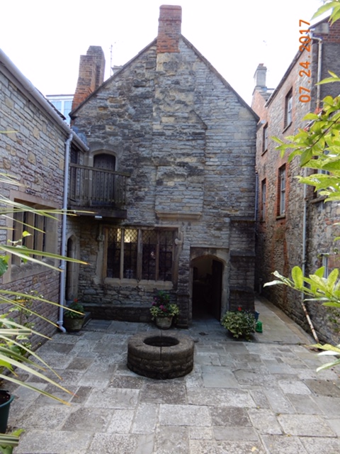
We found the Lake Village Museum showcasing a small community that thrived in the wetlands over 2000 years ago and was rediscovered in the early 1900s. The museum is housed in the Tribunal, a medieval townhouse on High Street.

Further down the street was the St Margaret’s Chapel and Almshouse dating back to the 13th century. The monks of Glastonbury Abbey built it as a hospital for pilgrims. After the Dissolution (boy – Henry VIII really had it in for the monasteries. We’ve been witness to the aftermath all over Britain.) the hospital was dismantled and later 2 rows of five almshouses were added for the town’s poor men. One row still stands, the other was demolished in 1957 (!) and the foundations were incorporated in the courtyard garden.

DSCN2316

The third day was sunny and warm. We walked up the Tor – a steep, hot climb – and enjoyed the fantastic 360* view offered. We joined many people, including a meditation class and children flying kites. The remains of a 14th century chapel stands at the summit and the shade it offered was welcomed. We could see Glastonbury at the base of the tor, we could see the town of Street, 2 miles further away. We could see Wearyall Hill and the Holy Thorn Tree at its summit and we could see the small cathedral city of Wells about 7 miles away.

At the base of the Tor is the Chalice Well, another legend-filled location. Returning to Arthurian legends, the Holy Grail is said to have been buried here and the iron tinged waters from the spring are supposed to have healing properties. In reality, the Chalice Well Gardens – according to the brochure – is a Living Sanctuary; a place to sooth the soul and revive the spirits. The well water flows from its source at the Lion head fountain through several pools and “rooms” of different garden plantings ranging from the profusion of flowering plants in the upper gardens terracing down to the shaded Yew trees and finally the lower lawns. It is very restful and shaded and cool and inviting.

Having recovered from our hot Tor hike in the cool of the Chalice Gardens, we continued to the Abbey. Most abbeys we have visited have been set apart and in their own grounds. Glastonbury’s main gate opens onto Magdalene Street – in the heart of the town. With the gates closed and without the large banners proclaiming the Abbey’s presence it almost could almost be mistaken for another store front. Behind the gates lies a 36 acre beautifully tended park the ruins stand in.

IMG_2327

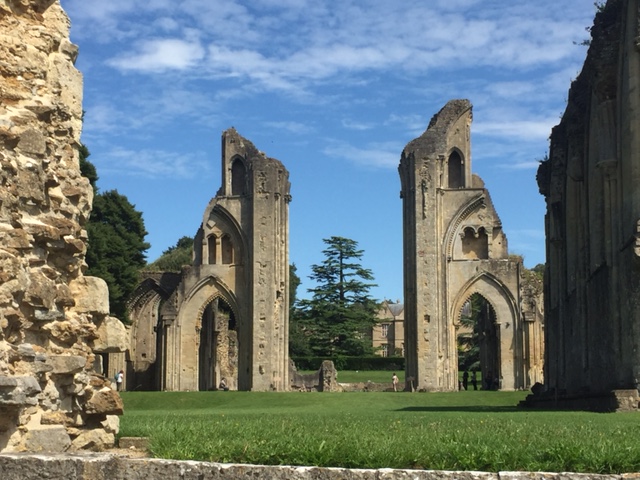
The abbey ruins have been photographed so often I’m willing to bet many people have seen them even if they were not sure what or where they were.
The abbey was the earliest Christian monastic site in Britain and by 1068 it was the wealthiest abbey in all of England with a worth placed at £846 (there has been a bit of inflation in the last 1050 years!)

A huge fire in the 11th century burned the whole thing to the ground leaving the monks penniless but resolute. In 1139 they devised a method to reel in the pounds by “discovering” King Arthur and Guinevere’s grave on the monastery grounds “proving” Glastonbury was the Isle of Avalon and making it a place of pilgrimage. Soon the cash was rolling in and they were able to rebuild the abbey to magnificent proportions.
The whole thing came crashing down in 1539 when the last abbot resisted the King and was found guilty of treason. He was hung, drawn and quartered on the top of the Tor (shades of Mel Gibson’s William Wallace), his abbey was dismantled and anything of value was sold off to the highest bidder. What was left is what we see today, a romantic look at days gone by and the legends contained within.

Thursday, July 27, we drive to Street to get new tires on the van and visit the Clark Village Outlet Stores; I’m looking for sandals. Friday we head for London Town.

The Eden Project

7/20/17 The Gardens of Cornwall – part 2:

Seventeen years ago, on our last visit to Great Britain, while traveling around Cornwall looking for the tin mining tailings we came across a massive construction site for the Eden Project. It was an abandoned porcelain clay pit that was being repurposed as a giant greenhouse containing plant life from all around the world. The site was conducting tours of the grounds and the giant biomes and introducing the concept to visitors. We knew when we returned to the United Kingdom this time, that we would absolutely be visiting the completed Eden.

IMG_2199340F109D-A512-49A6-8DE1-BB1200CCE4A7

The same architect who restored the Heligan Gardens came up with the idea of the Eden Project. In two immense biomes (geodesic domes) he envisioned and helped bring to life the largest “captive” rainforest and Mediterranean landscapes with plants from Africa, Australia and the Americas. Outside gardens continued the great variety of plant life. Original artwork is scattered throughout the project. It is one hell of an idea.
Cornwall and China are the two largest producers of porcelain quality clay. The exhausted clay pit the Eden Project occupies is 60 meters deep, the area of 35 football (soccer) fields and 15 meters below the water table. It took 5 years to terraform, build the biomes and acquire, grow and plant the millions of 6000+ varieties of plants. They “made” 83,000 tons of soil from recycled waste and created their own water system by cleaning the seeping water that drains into the pit. They even have a zip line – purported to be the longest in Britain – and we believe it!
It is a sight to behold. We could not have begun to envision what the end product would look like 17 years ago when we first came across the Project.
If this sparks your interest google “Eden Project” for even more information. And next time you’re in England, make sure you go to Cornwall and visit the Eden Project.
For your pleasure here are some of the 150 photos we saved:


The Gardens of Cornwall

7/20/17 – Cornwall

We are in Cornwall, the furthest west part of southwest Britain. For me, Cornwall conjures up tales of King Arthur and his Knights, Pirates of Penzance, St. Michaels Mount and Lands End. But Thursday and Friday it will be all about gardens.
Thursday we visited the Lost Gardens of Heligan.
The Tremayne Family owned the Heligan Estate for over 400 years. Each generation added to the development of the 200 acres that made up the estate, but after WWI the last Tremayne closed it up and moved to Italy. By mid century half of the estate had been sold, but for 60 years the remaining gardens lay neglected and became “lost” to the locals.
In 1990 a descendant of the Tremaynes turned a trained archeologist friend of his, on to the history of the gardens. This friend determined to bring the gardens back to life. It took ten years to bring them back and the project was billed as “Europe’s largest garden restoration project.” Now – along with the Eden Project – it is one of the more popular tourist destinations in Cornwall.
So here are our highlights of the Heligan Gardens:
There are easy walking routes around the estate and there are more challenging routes. The challenging routes involve steep paths up and down hills but they bring you to interesting destinations. One is The Jungle, with exotic plants that include fern “trees” fifteen feet tall. A raised boardwalk leads you through the jungle to a rope suspension bridge that is great fun to cross.

The Woodland Walk is great for children with lots of things to climb on, and it has the Giant’s Head and the Mud Maid:

The Home Farm raised heritage breeds of sheep, pigs, poultry and cattle. It also had a sawmill and a woodworking shop:

IMG_2130
White Park cattle – one of oldest breeds in England

The Garden is a feature all its own. A huge kitchen garden grows rows of vegetables and herbs interspersed with rows of flowers:

The Pleasure Gardens highlight a large grassy area bordered by the largest rhododendrons ever to be seen. We were walking under a canopy of greenery when we suddenly realized the trees were 150+ year old rhododendrons – and at least 20 feet high!

DSCN2045DSCN2044FullSizeRender

Now the Pacific Northwest grows Rhodies to be proud of, but they got nothing on the Heligan Rhodies. We missed the blooms by a couple of months but they must have been stupendous to see – the plants dressed only in green leaves were amazing. We copied a photo from the brochure so we all could see how they look in bloom.

We finished off the day with a continuation of our cribbage tournament (Peggy 17 wins, Bruce 16) and an Italian dinner featuring our kitchen window basil privacy hedge.


I Am Not A Number

7/17/17 Secret Agent Man:

In 1968 CBS aired a 17-episode British TV series entitled “The Prisoner.” In brief, it was the story of a secret agent who suddenly quit the service but was kidnaped and imprisoned in a beautiful but bizarre village from which there was no escape.  Besides being counter-cultural for its time, the series carried existential themes and was very influential to this young college student who watched it.  Patrick McGoohan produced and starred as No. 6, the only name allowed him.

The series was filmed in the Northern Welsh town of Portmeirion, built by an architect – Sir Clough Williams-Ellis – in an Italian Style. He wanted to show that architecture could enhance natural settings and yet be fanciful and colorful.
I knew the series was filmed in the village but it has been almost 50 years since I have watched it and memory is dimmed. (Note to self: make sure to find and watch the series when we get home.).

DSCN1974

The name Portmeirion is also used as a popular line of dishware that is best known for its botanical themes. The Portmeirion Pottery company is owned by the artist-daughter of Sir Williams-Ellis and is available at the village – and a lot of other retail outlets.

Since we were in Northern Wales we made it our goal to visit the village, now run by a charitable trust as a hotel. All buildings are available as hotel rooms and there are shops, a café, tearoom and a restaurant. It lies above a tidal estuary that is reachable via paths from the village and there is an additional 70 acres of wooded land surrounding the village.


A few photos are posted on line and we thought we had an idea of what we were going to see, but we WAY underestimated it. We walked through the archway entrance and into a miniature fairyland full of color and fancifulness.
I overheard one of the visitors mention that is was like being on a movie set and I had to agree. Besides the TV series, Portmeirion has been the inspiration for writers and musicians. Noel Coward wrote the play “Blithe Spirit” while staying there and the village is the setting for Festival No.6 which takes place every September. Needless to say, The Prisoner plays a pretty important role in the marketing of the village.

A 1965 Lotus 7 was featured in the series and while we were there a Lotus club was just completing a weekend stay at the village. There were Lotuses parked all over the place.
We thought Chester was a must see – and it is – but Portmeirion won my heart that day.

We were making a serious run south with our goal being The Eden Project in western Cornwall, the furthest most part of Britain, and a long trek. We had a long drive ahead of us after our morning at Portmeirion and it took its toll on us. After 5-6 hours and 141 miles of scenic but slow driving (never above 50mph and often in the 30s mph due to peaks and valleys) we finally made it to our camping in Newport, Wales where we promptly collapsed.
Newport was our day’s destination because we wanted to see the Romain remains at Caerleon.
After a nights rest, we drove to Caerleon, a blessed 7 miles away.
In its day, Caerleon was one of three major garrisons in Britain, the other two being Chester and York. It also has King Arthur associations, being a possible location of the mythical Camelot.
A great deal of the original fortress has been buried under the modern town, but there have been archeological digs uncovering the remains of the baths and barracks and a fine museum displaying artifacts found at the digs. A short walk away is what is left of the amphitheater, in recognizable condition for a neglected artifact 2000 years old.


Quite satisfied with our stop, we got back on the road – this time choosing to drive on the M roads – equivalent to our freeways – and made a short day of it by stopping south of Bristol at a port town. The weather is warm and muggy.

Wales

7/15/17 – Travel Day:

We crossed over into Wales today. This was not a particularly astounding feat since Chester is right on the border of England and Wales, but nonetheless we entered a new country.
It turned out to be castle day. Our objective was to visit Caernarfon Castle in northern Wales – the castle where the investiture of the Prince of Wales takes place. It is also across from the Isle of Anglesey, the location of the Celtic Druids’ last stand against the Roman army back in AD70 (spoiler alert: they lost.)
On our way to Caernarfon we passed 4 castles in the 67 mile drive from Chester; this leads me to believe that the Welsh – much like the Scots – were a major pain in the ass for the English.

We stopped at Conwy, a walled market town on the northern coast of Wales with a complete castle and the smallest house in Great Britain. The town boasts a stay from William Wordsworth whom it likes to claim, was inspired by a gravestone in the church to write his poem “We Are Seven.”


We crossed over to Anglesey and had a drive around, but while the island is verdant and lovely, its history was what caught my interest and we saw no sign of that.

06A6B3BA-E007-490A-A37B-38B14471066B

We arrived at Caernarfon (I dare you to pronounce that – it took me 3 days to get it right and retain it) and were immediately enchanted with the castle and the walled town. I’m beginning to think there are as many restored castle as there are ruins in this country. The current castle was built by Edward I, replacing a motte and bailey (wooden) castle constructed in the days of Norman conquest. It is another UNESCO World Heritage site, and it is still owned by the British Royal Family.

6D1A3592-BB5F-40B7-8A25-DE82643EBA4E
Caernarfon city walls
234A2D0F-253C-48E8-9E78-017A2A31DA65
Strait of Menai (Anglesey in background)

The castle and town lie on the eastern shore of the Menai Strait, opposite the Isle of Anglesey. I was unable to learn where the Romans attacked the Druids on Anglesey but I would not be surprised if it weren’t here, where the bay is shallow when tide is out. We walked about, looking for the best camera shot of the castle. We watched sailboats playing in the Strait with Anglesey in the background.

As we were leaving town we saw a sign directing us to Segontium, the old Roman fort manned by the army of General Agricola, who led the attack on the Druids. Of course we stopped to see it. It was at the top of a hill overlooking the Strait. The stone foundations of the fortress showed the typical orderly pattern the Romans used to lay out their camps.
Finally we got back on our way to Porthmadog and Portmeirion.

It’s Chester, not Cheddar

7/14/17 – Chester

Seventeen years ago, after our last visit to the UK, a good friend of ours – Tad – wondered if we had visited Chester. We hadn’t, but he spoke so highly of it, we put it on our bucket list should we ever return to the UK.
We were not disappointed. In fact, we had no idea we would as pleased with the town as we were.
I am all about ancient history and a lot of Roman history has survived the centuries via writings and ruins spread through what was once a vast Roman empire.
Chester was once a part of that empire. Founded around 70AD as a military fort – Deva Victrix – it was probably used to defend against Celtic tribes as the Romans advanced northward.
By the 5th century the Romans had left Britain and the fortress was abandoned. The Saxons arrived and the settlement was known Legacaestir – Old English for “City of the Legions.” Then the Normans conquered the island and Legacaestir became “Castor” (Latin for army camp) which, as the English language modernized, became Chester.
The Romans built walls enclosing their fortress and these walls have survived to this day. A two mile walk along the walls takes you all around the historic old city with great photo ops everywhere.


We began our wall walk at the Northgate. We passed the remains of the Roman Amphitheater and left the wall to visit the Roman Garden, an area with locally found roman relics. We saw where the walls had been breached during the English Civil War in the 1600s. We walked down to the River Dee to see the promenade, bridges and a fish weir. We walked along a portion of the river whose access to the sea made Chester the main seaport in the Northwest until the river silted up and Chester handed over its title to Liverpool.
We returned to the walls and passed the Cathedral Falconry and the cathedral. We walked under the 2nd most photographed clock in the country – Big Ben being the first. We glimpsed the famous Rows in the heart of Chester.
We walked past the Roodee, England’s oldest racecourse and once the Roman harbor before the river silted up and changed course. We passed the defensive tower where King Charles I watched the defeat of his army during the Civil War and had to flee for his life.
And then we descended into the city proper.
We were met with half timbered buildings ranging in age from 400 to a modern 150 years old. As we walked down Northgate we came across The Pied Bull, a pub that had been in business since the 1200’s and whose current building had been erected in 1547. That is 900 years of pouring beers!

We passed the stone archway that was the original entrance to the Chester Abbey. As with most other abbeys in England, it was dissolved in Henry VIII’s quest for separation from the Catholic Church. Someone in the church hierarchy was pretty smart though because a year later the abbey was reconsecrated as a cathedral of Henry’s Anglican Church, saving it from destruction. We saw the impressive Town Hall.
We finally reached the Cross; a junction of four streets: Northgate, Watergate, Eastgate and Bridge Streets. The Cross serves two functions that we could see; it is a meeting place and it introduces the Chester Rows.

DSCN1761
The Cross
DSCN1766
The Rows
IMG_1876
Queen Victoria Clock

The Rows are covered walkways with entrances to individual shops on the 2nd story level of buildings. The lower or street level is another set of shops. The walkways are continuous with access from the street level by way of numerous stairways. These Rows date back to the medieval era – probably around the 13th century and nowhere in the world is their equivalent.
They are along all four streets that make up the Cross. They are often contained within very architecturally distinctive buildings. They are a shopping Mecca with worshippers flocking to pay homage. They are picturesque as all get out.

We walked back to the Cathedral and upon entering it were treated to an organ recital. We walked about the interior listening to the music. Cathedrals are always amazing and this one was no different. Along the south wall are large mosaics representing events from the lives of Abraham, David and Moses and the cloisters are the first we’ve seen that are enclosed, usually they face out to an open green space.
We returned the next day to complete a couple of errands: Bruce got a badly needed haircut and we needed to start thinking of the most economical way to stay online after we left the UK.
We have been using SIM cards in our unlocked phone and iPad. Our first month on the continent we used the Lebara company’s data SIM card. We got it in Delft and for €20 we received 6GB of data. That, and available wifi use, was enough to last us for the month. When we reached the UK we were introduced to Three phone company. They had a phone/message/data package that gave us 12GB of data for 30 days for £20. We could use my iPhone as a hotspot and Bruce could connect through me to get online. We also purchased a 3GB data-only SIM for the iPad, good for 3 months. The 3 months will end about the time we return to the Continent and we wanted to purchase a SIM card that will last a year and give us 9GB data usage abroad. According to what research I could find, the deal for the 9GB was the best currently available so we wanted to buy it and be done.

IMG_0620

While Bruce was getting his haircut, the barber explained the activity that was happening outside. The Cathedral was closed to the public for the day and Northgate Street was being cleared of vehicles. A funeral procession was being made ready for.
In late May, you may recall, the city of Manchester had a terrorist attack at an Ariana Grande concert. Among the murdered victims was a policewoman from Chester. It was her funeral that the city was preparing for.
We thought back to yesterday’s organ recital at the cathedral and wondered if perhaps it had actually been a practice session for the funeral.

DSCN1816DSCN1817DSCN1819

Around 1:30 pm the procession began: a dozen police officers dressed in formal uniforms lined up as honor guard at the entrance of the cathedral. With great solemnity, elegance and dignity, the coffin was carried into the walled city by a horse and carriage, preceded by two mounted officers. Chester citizens lined the street to pay their last respects while in the background tourists, oblivious to the event took selfies in front of landmarks.
After the procession we made our way back to the bus station and returned to the camping to cook dinner and prepare for our departure.


The Lakes

7/12/17 travel days

We drove south through the Scottish lowlands stopping for the night at Gretna Green on the border of Scotland and England.
Gretna Green got famous when, 200 years ago, it became the destination for underage lovers running off to get married without parental consent.

IMG_3324

Talk about a tourist trap! Busloads of tourists come to see the “famous” blacksmith’s anvil where the marriages took place. The souvenir shops sell the kitschiest items for exorbitant prices and the lines at the register are long. Ugh.
And people still come to Gretna Green to get married.

We left Scotland and drove south through the Lake District.
Oh. My. Gosh. What a beautiful area.
Of course we’d heard of the Lake District just as we’d heard of the Yorkshire Dales and Moors, but you have to see them to appreciate them.
Years ago I read an opinion that the UK – with all its civilized land – was one of the most beautiful islands in the world. When we toured Britain in 2000 we heartily agreed with that assessment.
The Lake District is the most beautiful area we’ve seen in a beautiful country (Robin – remember we haven’t been to the Highlands. Call off the Floggers!) And I don’t have a photo to share that does it justice.

Our road took us through a necklace of fairytale stone villages sitting on glittering lakes with a backdrop of fields dotted with stone walls. Low lying mountains rimmed the vales where the lakes lay. It is so hard to describe the beauty of the area. Evidently we are not alone in that assessment because the Lakes District is visited by something like 23 million people each year and I think they all come in the summer.


FullSizeRender

We found a stone circle at Castlerigg on a hilltop and we spent the night at a camping in Keswick. The camping – and the town – sat on the edge of one of the lakes the district was named after. The view reminded us of Lake McDonald in Glacier Park (sans snow).
We drove through Grasmere, where the poet William Wadsworth lived for 14 years. We passed by Beatrix Potter’s village of Near Sawrey and made our lunch in Windermere. Eventually we passed through the Lake District and stopped outside of Blackpool on our way to Chester. We are not visiting Blackpool, known as a seaside resort with an amusement park, because we want to devote a couple of days to Chester, a town with Roman origins, before continuing to Northern Wales and then to the South.

The Da Vinci Code

7/9/2017 Rosslyn Chapel

Beginning our journey south, we made sure to stop at Rosslyn Chapel, the 15th Century Scottish chapel made famous by the book/movie “The DaVinci Code.” It is located just 8 miles south of Edinburgh proper and has many mysteries associated with it. Was it a Templar chapel? Is the St Clair family descendants of Mary Magdalene? Is there a secret vault beneath the crypt? Did the master stonemason really kill his apprentice in a fit of jealous rage? These are just a few of the mysteries promoted by authors and conspiracy theorists over the centuries.

We found no answers to those questions but, like so many before us, we were enchanted by the chapel. It seems that every bit of masonry has been carved. It was considered a collegiate church which meant it was a teaching church so most of the stonework told stories for the illiterate. It took over 40 years for the stonemasons to complete their work.

IT WAS SMALL!!!! As we entered the chapel we were stunned by its diminutive size.
We stayed to listen to a talk about the chapel and its history and then explored the chapel more closely. We saw the famous master and apprentice pillars; the apprentice pillar completely outclassing the master’s pillar the tale of the jealous, murderous master. Carvings depicted all sorts of things: a devil and lovers; an angel with bagpipes, members of the St. Clair family – owners of the chapel; green men; seven deadly sins, seven acts of mercy, on and on. It was fascinating.

We couldn’t take photos of the interior so you’ll just have to watch the movie or look at the two photos I found online (no photo credits this time).

We left the chapel and began our drive back to England. The weather held for us during our time in Edinburgh but rain has returned and looks to stay for the time we allotted for Scotland. We decided to bypass Sterling and Glasgow and instead head for drier weather.

Edinburgh

7/6/17 – Edinburgh

IMG_0520

Upon our arrival at Mortonhall, and since we were staying for several days, we decided to put up our awning room. It was the first time we had an opportunity to erect it since we bought it. We were a little nervous about remembering how to do it, but while we were slow, we succeeded.


IMG_0538
Unveiling of Edinburgh
IMG_0537
Tiny shops

Thursday we took bus number 11 out of Mortonhall and a twenty minute ride took us into our “hidden” city of Edinburgh. The city slowly revealed itself to us along the route climaxing with the dominating view of Edinburgh Castle up on Castle Rock.
We got off the bus.


And walked around the rock slowly making our way up to the castle itself. We were blown away by the rock on which the castle stands. It is the remains of an extinct volcano made of a type of very hard basalt rock that resists erosion. Rocky cliffs protect three sides of the castle and it was a nearly perfect defensive location to build a castle. As we walked around the Rock we ogled the cliffs making jokes about attackers failing to scale the cliffs. We later learned that in the 1300s, soldiers loyal to Robert the Bruce did successfully scale the cliffs and defeat the English who were holding the castle. Edinburgh Castle lays claim to being the most besieged castle in Great Britain with 26 sieges in its 1100 year history.


The castle grounds were fabulous with many sandstone buildings, round towers, cobbled walkways, the oldest building in Edinburgh: 12th Century St. Mary’s Chapel, the Scottish Crown Jewels and the magnificent Scottish National War Museum.


At one pm everyday, a really big, really loud cannon is shot off to the delight of visiting crowds, allowing citizens to check the accuracy of their watches and clocks – a tradition dating back 150 years for ships in the harbor to adjust their chronometers.


We walked part of the Royal Mile, the succession of streets running from the Castle to Hollyrood Palace (the official residence of the Queen – who happened to be in town and no, we didn’t get to have tea with her) but took a sharp left down the hill towards Princes Street where we found lunch at a Kebab shop. It is said these two streets are the busiest tourist streets in all of Edinburgh and boy, were they!


Friday we visited the Royal Brittania, the last royal yacht in service to the British monarch. It was decommissioned in 1997 after 43 years of service in a ceremony that I bet broke the Queen’s heart.
Entry fee included an excellent audio tour. It explained the history of the ship as well as how the crew and the Royal Family lived while aboard. It was very luxurious and yet comfortable at the same time. I read somewhere the Queen felt the Brittania was the only place she could really relax.
The ship is located at Ocean Terminal – a one hour bus ride from our campsite (we sat upstairs on the double decker bus and received a great tour of the city). We expected it to be on a dock much like the Queen Mary in Long Beach, CA or the USS Midway in San Diego, CA but instead access was through a huge shopping mall. Our first stop was H&M. A couple of tops later we proceeded onward to the ship.
We are realizing that – much to our chagrin – we no longer have the stamina to put in 8-9-hour days of sightseeing. 5-6 hours is about our max so the Royal Brittania was our exclusive event for the day.

Saturday, our last in Edinburgh was filled with a walkabout. We wanted to see Sherlock Holmes, Greyfriars Bobby, more of the Royal Mile and Princes Gardens.


Returning from the Brittania yesterday we saw a pub named the Conan Doyle. Sir Arthur Conan Doyle was the author of Sherlock Holmes. We had been on the bus and missed the photo shot of the pub so we decided to return. A little research determined the pub was very near to where Sir Arthur was born and a little more research pointed us to a statue of Sherlock Holmes marking the birth spot.

Our next project was to find Greyfriars Bobby. This was a little terrier whose master died in the 1880s. Bobby held vigil at the grave for 14 years earning the respect and admiration of all who tried to chase him away. On his death he was buried in Greyfriars cemetery near his master. A statue of the dog commemorates his loyalty.


Following our tourist map was a bit tricky and as we navigated our way to Bobby, we came across Grassmarket a historic market place and current open air market. It has the oldest pub in Edinburgh, the White Hart Inn, and was notorious for daily hangings up to the 18th century. Passing by we walked down Candlemakers Way and into the entrance of Greyfriars Church with its large graveyard of weather beaten tombstones.


One newer marker was Bobby’s but we saw no statue. I was greatly disappointed; we split up to search better but with no success. I returned to the displayed map and finally saw that the memorial was outside the church walls. The statue was in front of a nicely appointed pub named Greyfriars Bobby. Once found, we waited our turn while a tour group of Italian teenagers got their photos with the pooch.


We began walking uphill towards the Royal Mile and suddenly we came across The Elephant House – the very tea and coffee shop where J.K. Rowlings wrote the first couple of Harry Potter books. That was a welcome surprise!

DSCN1600DSCN1588DSCN1587

Reaching the Royal Mile we detoured into St. Giles church at Parliament Square, just in time to listen to a choral concert and take photos of the lovely stained glass windows. We decided not to visit Holyrood Palace – which was just as well since it was closed due to the Queen’s presence – and walked down to the Scott Monument, honoring Sir Walter Scott. The prolific author is obviously held in high regard; the monument is the largest monument to a writer in the world.

DSCN1519

We walked the Princes Gardens and right into the Scottish National Gallery, a splendid neo-classic building with an impressive collection of great works by Scottish and foreign artists. I love me an art museum and if it hadn’t the last stop in a long day I would have stayed for a longer time. At it was, I saw paintings by John Constable, Raphael and Leonardo, among others.
Finally, we hopped on our bus #11 and returned to the camping where we took down the awning room in preparation for Sunday’s departure.

Our new found German friends from St. Andrews, Ingrid and Hans, were staying in the same campground. After our respective dinners we got together and spent a couple of hours chatting and sharing travel stories.

We love visiting the great cities of the world and Edinburgh definitely belongs in that category. Our three days were packed with attractions and we just scratched the surface. With more time and knowledge we would have covered more ground and enjoyed it on an even deeper level.

The Home of Golf

7/5/17 St. Andrews

Having crossed the border into Scotland, we had two places on the top of list of places to see: Edinburgh and St. Andrews. While it has never held much fascination for us, we know people who love the game of golf. Having come so far, there was no way we were not going to visit St. Andrews.
St. Andrews is consider the “home of golf” because it was being played there as far back as the early 1400s. It is also home to a university that goes back even further than its golfing origins.

We arrived in the late morning and were able to park right across from the links course.


I want to tell you… this place radiated reverence. I am not a fan of golf – except to watch on tv when nothing else is on – and yet there was something about being on a golf course that is 500+ years old that got to us. It was like being in one of the architecturally awe-inspiring cathedrals we are so nuts about. We are known for our enthusiasm (how is that for a euphemism for animatedly loud?) but we walked around the links as though we were in a church.
There were lots of players on the courses. We wondered; were they feeling as reverential as we two non players?

FullSizeRenderIMG_1571


As we walked around the Old Course we found the landmark stone Swilcan Bridge at the 18th hole, whose backdrop was the The Royal and Ancient Golf Club of St. Andrews Clubhouse. A dignified stone building built in 1854, it is a members only club that didn’t allow women members until 2015. Since I don’t play golf, I’ll refrain from commenting.

17F7C871-38AF-440D-B760-18718DB3B739IMG_1569

There was a memorial tournament going on with American golfers joining an international cast, and at the public clubhouse and in town there were scores of souvenir stores selling all things related to golf.
We returned to the van and met a German couple Hans and Ingrid who are touring Scotland for a bit. While in Perth, they received a ticket for parking in an area that did not allow camping vans. They needed some help with translating the ticket and asked if we could help. It was a hefty penalty – £60 but if they paid it quickly – in person, by check or online – it would be reduced by half. They were no longer in Perth and their wifi connection wouldn’t work, so we offered to help and using my iPhone we were able to get their payment sent off.
On our return we re-crossed the Firth of Forth – another name I’ve heard forever. Firth means estuary, Forth is the river = Estuary of the Forth River as it empties into the North Sea.

FullSizeRender
The three bridges crossing the Firth of Forth. Taken from Ocean Terminal.

Three bridges cross the Forth there;
The old cantilevered iron railway bridge built in 1882 at the height of railroad power, is considered a symbol of Scotland AND its a UNESCO world heritage site;
The Forth Road Bridge is a twin-towered suspension bridge erected in 1964 to carry road traffic. It modernized the centuries-old ferry system, previously used to transverse the river. What struck me was the idea that in the 20th century ferries were still the only way for people and vehicles to cross the 1.5 mile expanse. I think the bridge was badly needed.
Our travel mentors – Robin and Alimay have a direct connection to the Forth Road Bridge: Robin’s father was largely responsible for its design.
I wish I had taken a better photo of it, but as we crossed I was entranced by the Iron Bridge on our left, as well as the new soon-to-be-opened Queensferry Bridge on our right.
As we drove towards Edinburgh we kept remarking how the city (at least the old city, including the castle) was hidden from us. Greenery and housing developments blocked any chance of seeing the city. Even as we reached our camping – Mortonhall – we would never has suspected we were on the outskirts of a major city, we could have been in any one of the small towns we have driven through.